[soliloquy id="12541"]
DELAWARE (10/2/2015) Gov. Jack Markell declared a limited state of emergency for Sussex County today as high tides and winds are expected to cause moderate to major coastal flooding, with many coastal roads already under water.
State offices will remain open and there are no driving restrictions.
Residents of flood-prone areas of Sussex County (see list below) and throughout Delaware are at risk of significant flooding, Markell said, and he urged residents of those areas to seriously consider taking precautionary measures, including evacuating voluntarily or planning for potential evacuation and use of travel routes around flooded streets and roads.
“Though predicted rainfall totals have dropped and the expected path of Hurricane Joaquin remains well off-coast, high winds and coastal flooding will significantly impact Sussex County,” said Markell. “State and local officials are taking the necessary steps to prepare for possible evacuations and road closures and the National Guard has been deployed to Kent and Sussex Counties to support those efforts, as needed.”
At 2 p.m., the Delaware Environmental Observing System reported that 3.79 inches of rain had fallen at Indian River Inlet, with numerous other coastal locations recording more than 3 inches of rain.
At noon, about an hour before scheduled high tide, Delaware Bay waves were crashing up to the dune line at Slaughter Beach, in northern Sussex, and the wind had picked up enough to rock vehicles parked at the Memorial Fire Company lot adjacent to the beach as a steady stream of visitors came to observe the water.
Some schools and state park campgrounds are closed today and some other activities canceled in advance of a nor’easter expected to bring wind gusts to 60 mph, heavy rain and coastal flooding.
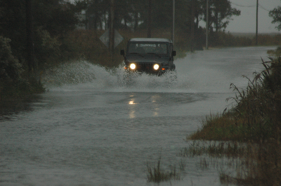
Just before 11 a.m., DelDOT reported flooding on several roads in Kent and Sussex counties, including Front Street in downtown Milford at the Mispillion River (see Twitter feed below for latest updates).
Indian River and Cape Henlopen school districts as well as Sussex Academy announced they would be closed due to the weather.
Caesar Rodney School District has canceled all after-school activities today but said Boys & Girls Club would operate on a normal schedule.
The Sussex Central vs. Sussex Tech football game has been rescheduled for Saturday, Oct. 3, at 7 p.m. The game will be played at Sussex Central.
Campgrounds at Cape Henlopen State Park near Lewes, Delaware Seashore State Park at Indian River Inlet and Trap Pond State Park near Laurel were to be closed at 8 a.m. today because of the severe weather expected ahead of Hurricane Joaquin.
Campers are being given the option to relocate to state park campgrounds at Killens Pond near Felton or Lums Pond near Kirkwood, officials of the Delaware Division of Parks and Recreation announced.
Park guests en route or already checked into cabins at Cape Henlopen or the Indian River Marina will be allowed to stay. Cabins at Trap Pond State Park will be closed.
Surf-fishing crossings at Cape Henlopen, Delaware Seashore and Fenwick Island state parks will be closed through the weekend.
Day-use areas in the coastal parks and Trap Pond will remain open until further notice, officials said.
The National Weather Service issued a high-wind warning for Sussex County until 1 a.m. Saturday, with gusts up to 60 mph possible.
Coastal flood warnings are in effect until Sunday night for Sussex, Kent and New Castle counties, with widespread flooding expected at high tides and 6 to 10-foot breaking waves along the ocean.
High tide on the ocean begins about 11:30 a.m. today and midnight tonight, and at later times on Rehoboth, Indian River and Delaware Bays and the Delaware River and tributaries.
The weather service said numerous roads will flood and there will be moderate beach erosion. Flooding was reported Thursday on River Road in Oak Orchard and on Prime Hook Road west of Prime Hook Beach.
Many events scheduled for the weekend have been canceled due to the expected weather, including the University of Delaware’s annual Coast Day at the Lewes Campus.
The Delmarva Amateur Radio and Electronics Expo scheduled Saturday at Sussex Technical High School also has been canceled.
DelDOT has lowered the speed limit on Interstate 495 to 45 mph.
DelDOT traffic reports via Twitter
Flood-Prone Areas of Sussex County listed by Gov. Markell
Sussex County Delaware Bay Communities
Slaughter Beach
Prime Hook Beach
Broadkill Beach
Lewes Beach, east of the Lewes & Rehoboth Canal
Sussex County Ocean Coastal Communities
Areas within ¾ of a mile of the coast in the following communities:
Henlopen Acres
Rehoboth Beach
Dewey Beach
North Bethany
Bethany Beach
South Bethany
Fenwick Island
Sussex County Inland Bay Communities
Areas surrounding the Rehoboth Bay, Indian River and Little Assawoman Bay
Flood-prone areas south of Route 24 (John J. Williams Highway) including Angola, Long Neck and Oak Orchard
Flood-prone areas along Route 26 (Vines Creek Road and Atlantic Avenue)
Flood-prone areas along Route 54 (Lighthouse Road)
Sussex County Western Communities
Flood-prone areas in close proximity to the Nanticoke and Broad Creek Rivers
Read the governor’s emergency declaration